
'Very significant' waves, storm surge expected as Hurricane Fiona barrels towards Newfoundland


Hurricane Fiona, which has weakened to a Category 3 storm, is expected to cause dangerous storm surges along Newfoundland's south coast and possibly record high water levels in the Port aux Basques area, says Environment Canada.
In an update Friday afternoon, Canadian Hurricane Centre meteorologist Bob Robichaud said the waves caused by Hurricane Fiona will be "very significant," and the southwest coast of Newfoundland will be the hardest-hit area in Newfoundland and Labrador.
"What we're expecting is the centre of the storm to track very close to the coast," he said.
Fiona was forecast to pass northwest of Bermuda on Friday morning and then pick up speed as it heads for Canada, where it is expected to make landfall in eastern Nova Scotia later Friday before moving into the Gulf of St. Lawrence and swiping southwestern Newfoundland on Saturday, according to the U.S. National Hurricane Center.
"It's a major hurricane, and it's only 900 kilometres away from us, and it's getting bigger," Robichaud said. "All that momentum is trapped within the storm, so it's very difficult for something like that to actually wind down."
"The one area that's really getting it all is the Port aux Basques area," said meteorologist Rob Carroll of Environment Canada's Gander weather office on Friday.
Newfoundland's southwest corner, from Gros Morne on the Northern Peninsula to François on the south coast, is under a hurricane warning.
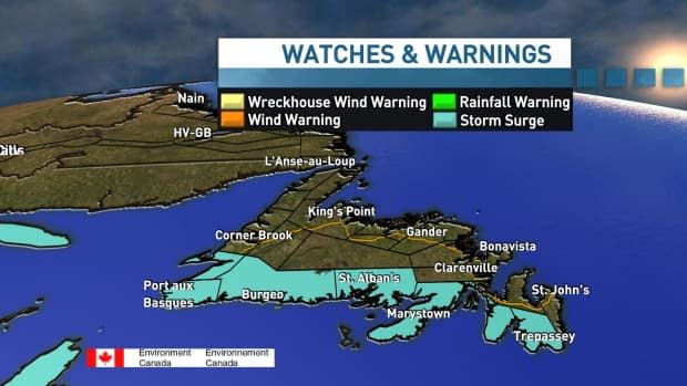
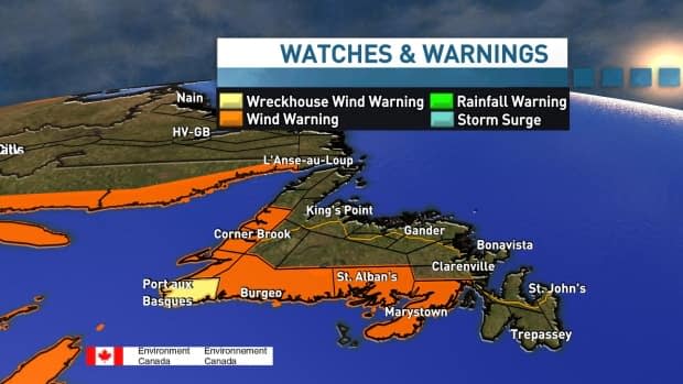
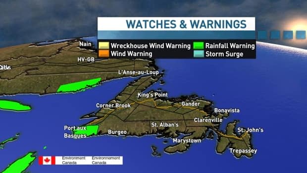
Meteorologists expect 70 to 100 millimetres of rain in the Port aux Basques area and there's a wind warning in effect from Gros Morne along the south coast to the Burin Peninsula: sustained winds up to 100 km/h, with gusts to 140 km/h in most areas but as high as 170 km/h in Wreckhouse.
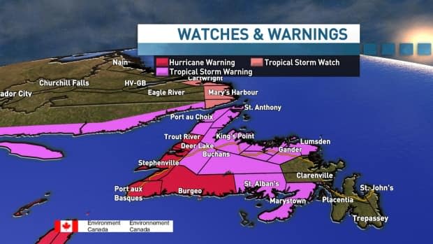
All of Newfoundland's south and west coasts are under a storm surge warning, and it's the possibility of dangerously high water levels that have meteorologists concerned about damage.
"That's what I think will be the most significant impact along with the wind," said CBC meteorologist Ashley Brauweiler.
Carroll agrees.
"We're looking at the potential for maybe near or even the highest water levels they've ever seen, so that could be quite, quite dangerous, quite damaging," said Carroll.
Meteorologists say waves will be in the 10- to 12-metre range, possibly higher, and waves will coincide with high tides — on Saturday around 11 a.m. NT and again at 10 p.m. — which will generate the storm surge.
"If you do have any interest near the water, it is a good idea to move to higher ground if you are in those situations," Brauweiler said.
The storm could also be one of the deepest pressure systems to affect the Atlantic Canada region, with current minimum pressure of 936 millibars. The lowest-pressure system recorded in Newfoundland was 940 millibars in St. Anthony in the 1970s.
"All the ingredients are really there for some high water levels, flooding and potential damage," Carroll said.
Brauweiler said the winds will ramp up in the Port aux Basques area around 6 a.m. Saturday and last into the evening.
"This isn't just going to be for a few hours and that's kind of part of the reason why this will potentially be a fairly severe storm. It's because we're going to see these winds for a long period of time," she said.
Staying safe
According to a provincial government press release issued Friday afternoon, staff in the Department of Transportation and Infrastructure have been checking culverts and removing debris that could block water flow. The provincial emergency operations centre has been activated.
"Updates on highway driving conditions and potential damaged infrastructure will be provided as quickly as possible," said the release.
The provincial government asked residents in impacted areas to stay home during the storm, if possible, and have enough supplies to last for 72 hours. The government also recommended that residents clear drains and basins, secure loose items outside and check on neighbours.
The province said power companies and the regional health authorities will activate emergency and contingency plans if needed.
