
Florida is in the storm cone. What it means for you and what you should be doing
Depression Nine is churning in the Caribbean Sea and it likely won’t be long until we see a tropical storm form.
The National Hurricane Center’s forecast calls for the system to turn into a tropical storm some time Friday, and then strengthen into a hurricane in the coming days. The hurricane center expects the storm could make landfall somewhere in Florida next week around Wednesday, potentially as a Category 3 hurricane.
Another depression in the eastern Atlantic formed into Tropical Storm Hermine Friday afternoon, though that one is not a threat to Florida or the rest of the United States.
Forecasters are cautioning that there’s a lot of uncertainty over the Caribbean system’s track, which has most of Florida in its cone of uncertainty. Instead, forecasters say people should be checking and preparing their hurricane supplies to make sure they’re ready, just in case.
But what does it mean that Florida is in the cone of uncertainty? And what should you be doing right now?
Here’s what to know:
What is the cone of uncertainty?
The National Hurricane Center’s “cone of uncertainty” tells you where forecasters think the center of the storm — its eye — is going to be up to five days out. Sometimes referred to as the “cone of concern,” the cone is a way for forecasters to visually show the storm’s expected track. The letters on the graphic indicate how strong the storm will be:
D stands for tropical depression, S for tropical storm, H for hurricane and M for major hurricane, which is used for storms that are Category 3 or higher. Because of better forecasting, the National Hurricane Center’s cone has become smaller through the years.
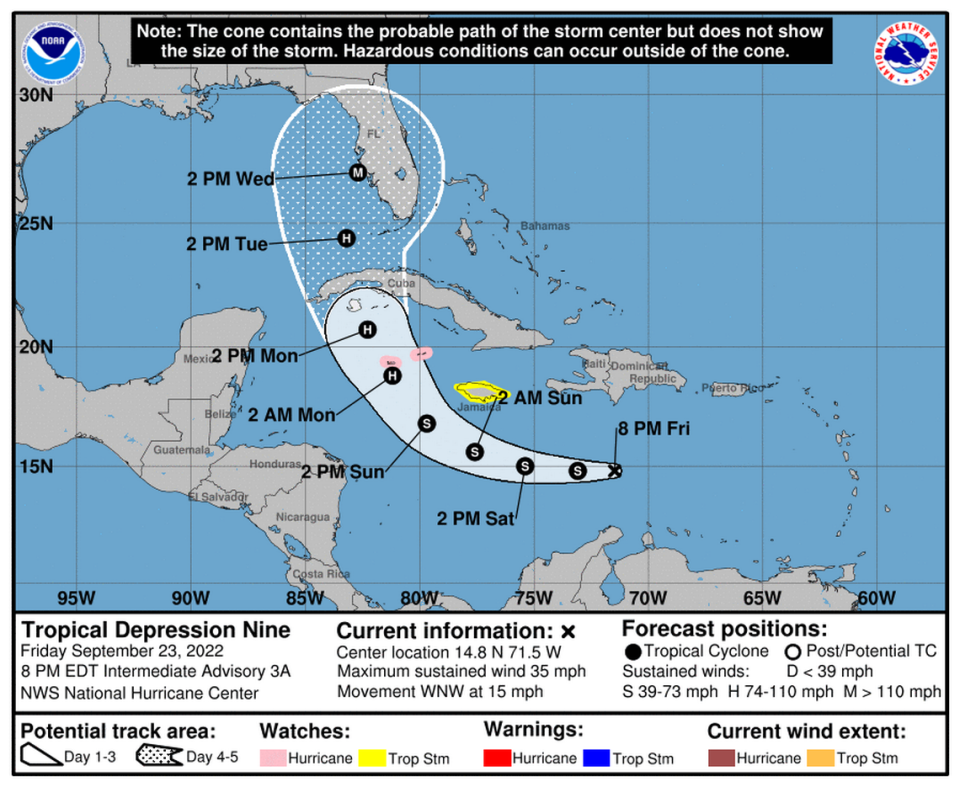
But the cone doesn’t represent the size or intensity of the storm, or if forecasters have uncertainty in a storm’s track, which can shift at any moment. And just because you’re outside the cone doesn’t mean you won’t feel a storm’s winds or rain.
READ MORE: The ‘cone of uncertainty’ is getting smaller — but it still matters if you’re outside it
Most of Florida is in the cone. What should I be doing now?
All of Miami-Dade, Broward, the Keys and much of Florida are in the cone of uncertainty for the system that could soon be a hurricane. There’s a lot of uncertainty in the storm’s track, including where it will make landfall, and it’s too soon to say what impact the system will have in South Florida next week.
Forecasters will have a better idea of the storm’s projected path and possible impacts in the coming days.
READ NEXT: What will potential storm do to weekend weather in Miami — and that big Dolphins game?
For now, Larry Kelly, a meteorologist with the National Weather Service in Miami, says people should start preparing and checking their hurricane supplies and continue to keep up with the latest forecast.
People in South Florida and the Keys need to have their storm prep done by Monday night, according to Jamie Rhone, the hurricane center’s acting director. Based on the current forecast, the weather service expects tropical storm conditions Monday night through Wednesday in South Florida.
Here are some of the things you should be doing now:
▪ Prep your hurricane kit if you haven’t already.
Each person in your home should have canned and/or nonperishable food for at least seven days and at least one gallon of water per person. Make sure you have enough food and water for your pet, too.
After you've put together your emergency kit, remember to maintain it so it's ready when you need it. Store your kit in a designated place where everyone in your family knows where it is kept. #BeReady pic.twitter.com/kmHV8ZbAnq
— Miami-Dade County EM (@MiamiDadeEM) September 23, 2022
▪ Fuel up your car, charge your power banks, withdraw cash and buy any supplies (food, water, medicine, etc.) you still need.
▪ Inspect your shutters, roof and fences in case repairs or replacements are needed. Prune your trees, as needed. And find out where you can safely park your car if the storm does come your way.
▪ You may want to start bringing your patio furniture and potted plants inside and tie down anything that could become airborne. If you have a boat, secure it properly. And once the storm gets closer, bring your pets inside too.
▪ Check to see if you live in an evacuation zone and discuss possible evacuation routes with your family, just in case.
In Miami-Dade, check your zone at miamidade.gov/hurricane. In Broward, visit broward.org/hurricane. In the Florida Keys, visit monroecounty-fl.gov/897/Evacuation-Information. If you’re planning to spend the storm elsewhere in Florida, the Florida Division of Emergency Management has online maps you can refer to for all 67 counties.
▪ Monitor local news for updates from the National Hurricane Center, your local National Weather Service office and local officials on the storm’s track, what type of hazards to expect and if there are any evacuation orders in effect. Plus, you’ll have an idea as to whether you’ll need to put up your hurricane shutters or not.
Miami Herald Reporter Devoun Cetoute contributed to this report.

