
Snowy Sunday to make travel tricky in parts of southern Ontario
Mother Nature is not letting southern Ontario catch much of a break after the significant storm earlier this week, bringing another dose of snowy weather this weekend as we enter the final days of January. If you have any travel plans, make sure you plan ahead because you could encounter some interruptions on the road.
PHOTOS: Blast of heavy, wet snow coats Ontario like wintry cement
The first of two clippers reached southern Ontario into Saturday morning, with the second clipper system expected to bring about 5-10 cm expected for most areas, as much as 10-15 cm possible for areas across higher terrain northwest of the Greater Toronto Area (GTA).
This won't be the end the snow, however.
Winter weather travel advisories are widespread across southern Ontario for the secondary system, along with special weather statements for some areas.
Motorists should expect hazardous winter driving conditions and adjust travel plans accordingly. Surfaces such as highways, roads, walkways and parking lots may become icy and slippery.
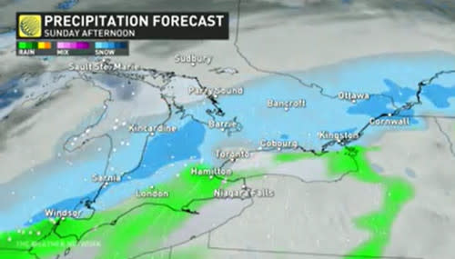
We’ll see precipitation begin across southwestern Ontario later Saturday evening, before moving into the GTA in the overnight period.
Eastern Ontario will see precipitation beginning early Sunday morning with the snow ending across the province throughout Sunday afternoon and evening.

Widespread snowfall accumulations of 5-10 cm are expected, with a swath bringing 10+ cm from Lake Huron through to eastern Ontario and extending into southern Quebec.
Warmer temperatures nudging in from the south could allow for some mixed precipitation and even rain to mix in along the shores of Lake Erie and the Niagara Peninsula, but this will be a snow event for most everyone.
Wintry weather continues next week with colder-than-seasonal temperatures dominating. In fact, it's shaping up to be the coldest weather of the winter thus far late next week and into the weekend. Ottawa should see its first -20°C temperatures of the winter, with even -20°C pressing into southern Ontario away from the lakes.

Some snow is possible at times, but the storm track should shift well south of the region for most of the week.
A much milder and more active pattern is expected for the second and third week of February.
Thumbnail courtesy of Shuttershock.
Stay with The Weather Network for the latest on conditions across Ontario.

