
Move over, earthquakes. California’s next ‘Big One’ could leave Fresno underwater
Californians are practically born bracing themselves for the “Big One.”
For decades the “Big One” meant a giant earthquake. More recently, severe drought and wildfire entered the picture. Now it’s time to make room in the natural disaster lexicon for an extreme megaflood. One that would leave much of the Central Valley, including Fresno, underwater.
So says a new study published by Science Advances that has received widespread media attention. Its authors claim California is actually overdue for a megaflood event, which they’ve given the biblical name “ArkStorm.” Also that climate change has nearly doubled the odds of one occurring every 25 to 50 years.
“Something that was once possible, but unlikely, in our own lifetimes, has become quite likely in our own lifetimes,” said Daniel Swain, a climate scientist at UCLA.
Using computer modeling, Swain and co-author Xingying Huang compared the results of two extreme weather scenarios: a once-a-century atmospheric river and another between the years 2081 and 2100. Both produced month-long storms that dumped 100 inches of rain in the Sierra foothills and even more precipitation at higher elevations.
Opinion
More than enough to overwhelm our state’s water collection and conveyance system and cause wide swaths of destruction.
The very idea of a megaflood may sound inconceivable — especially during prolonged drought — but it’s happened before. Most recently in 1862, and likely five times per millennium before that, the authors said.
“On human time scales, 100 or 200 years sounds like a long time,” Swain said. “But these are fairly regular occurrences.”
It may seem a bit strange to be talking about rising risk of a California #megaflood amidst severe #CAdrought. But it's not as paradoxical as it might seem at first glance--a topic I discuss extensively in my new Weather West overview of our work: (14/n) https://t.co/P0tajwHteX
— Daniel Swain (@Weather_West) August 12, 2022
Redux of devastating 1862 flood?
California history buffs should already know about 1862, when flooding devastated Sacramento (causing widespread destruction and forcing the state legislature to pack up and move to San Francisco) and transformed much of the Central Valley into an inland sea.
Fresno didn’t become an incorporated city until 1885, 13 years after its founding as a railway station. In 1862, there weren’t many folks around these parts.
Lucky thing, too. Because historical accounts say the flooding produced a 300-mile long, 20- to 60-mile wide inland sea that filled almost the entire Central Valley.
“Nearly every house and farm over this immense region is gone,” wrote William H. Brewer, a Yale-educated scientist hired by the state of California to survey its natural resources.
“There was such a body of water … that the winds made high waves which beat the farm homes in pieces. America has never before seen such desolation by flood as this has been, and seldom has the Old World seen the like.”
In his reports to the state treasurer, Brewer estimated that “over one-fourth of all taxable property of the state has been destroyed.”
Certainly, much has changed since 1862. The state’s population back then was roughly 500,000. Today it’s nearly 40 million. We’ve also constructed a series of reservoirs, levies, bypasses and canals to both store and transport water and protect against floods.
1997 a mere trickle by comparison
Those measures proved largely successful during Fresno County’s last significant flood in January 1997. At the time, Millerton Lake was so inundated with inflow from the San Joaquin River that Friant Dam operators were forced to far exceed the maximum allowable discharge of 8,000 cubic feet per second. At peak flow, water gushed through the dam’s four hollow jet valves — and spilled over the top — at 59,770 cfs. Nearly four times the previous record.
The resulting surge wiped out a bridge in Friant and flooded the nearby San Joaquin River Hatchery as well as the Fresno County Sportsmen’s Club on Lanes Road. In Firebaugh, which sits along the San Joaquin, half the town was evacuated as residents protected their homes with sandbags.
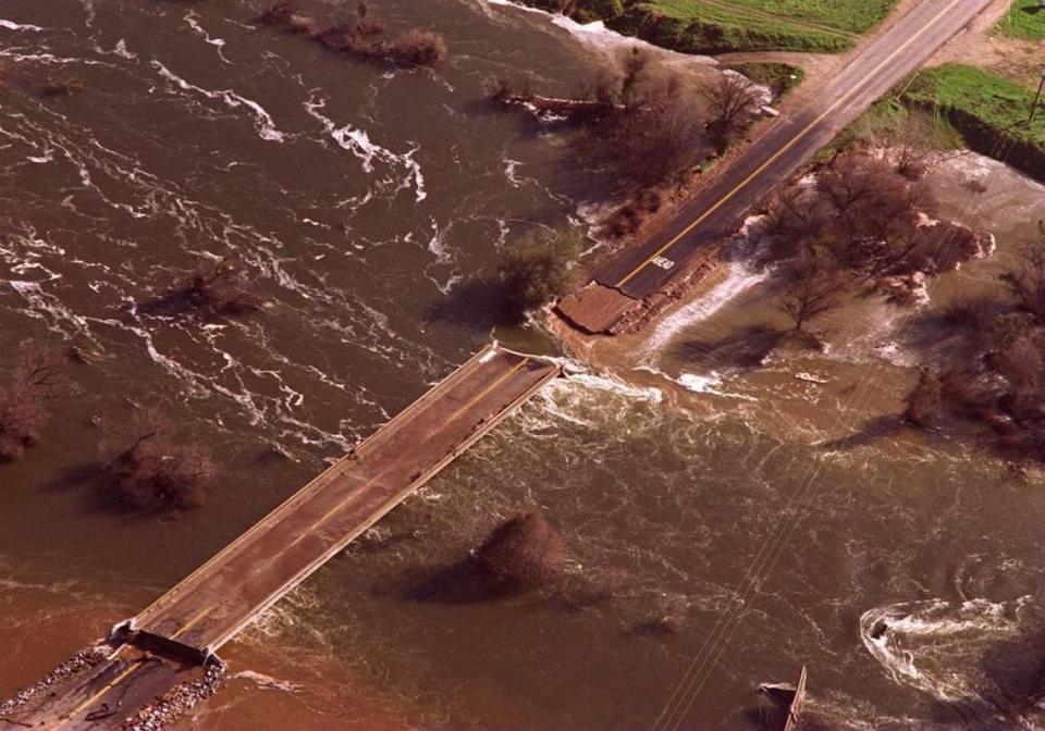
Local news reports described the 1997 flood as a “once a century” event. But compared to 1862 and what is being projected by the study’s authors, 1997 was a mere trickle.
A megaflood would devastate not only Central Valley cities such as Fresno, Sacramento and Stockton but also impact Los Angeles and the Bay Area. The resulting losses of homes and infrastructure could eclipse $1 trillion, making it the most expensive natural disaster in U.S. history.
“Every major population center in California would get hit at once — probably parts of Nevada and other adjacent states, too,” Swain said.
The study’s authors say their intent is not to provoke fear and angst but to help state officials prepare for the megaflood they say is a matter of “when” rather than “if.”
Unfortunately, those folks already have a full plate at the moment dealing with historically destructive wildfires, our dwindling water supply, rising sea levels and a slew of climate change-related goals and initiatives.
I’m skeptical how many more natural disasters and global warming crises California can realistically prepare for. But if Fresno and the Central Valley ever end up underwater during our lifetimes, we’ll sure wish we had.
