
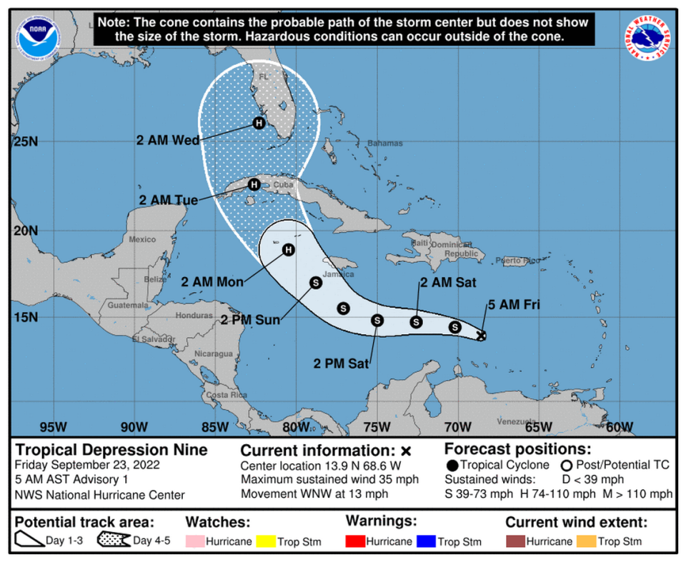
Tropical Depression 9 forms in Caribbean and could become Hurricane Ian in the Gulf
Tropical Depression 9 has formed in the Caribbean and will likely make landfall in the U.S. next week, the National Hurricane Center reported Friday morning.
The storm is forecast to intensify over warm water and could hit Florida early Wednesday, possibly as Hurricane Ian, since Tropical Storm Hermine formed just of the African coast Friday.
Heavy rain and flooding are expected in Aruba, Bonaire and Curaco, spreading into Jamaica and the Cayman Islands in the coming days.
The first “cone of uncertainty” track takes the storm over western Cuba and into the Gulf of Mexico, where it is expected to hook toward the western coast of Florida.
The cone of uncertainty changed throughout the day Friday. Initially it was predicted to make landfall in extreme southwest Florida early Wednesday. At the 11 a.m. CT report, the track changed to landfall at 8 a.m. a little farther north.
The 4 p.m. CT report Friday shows possible landfall at 2 p.m. Wednesday, south of Tampa.
“Early next week the system is forecast to move near or over western Cuba as a strengthening hurricane and then approach the Florida peninsula at or near major hurricane strength, with the potential for significant impacts from storm surge, hurricane-force winds and heavy rainfall,” the NHC reported.
As South Mississippi residents continue to watch the tropics, the five-day forecast from the National Hurricane Center has TD 9 and four other disturbances on the Atlantic map.
Tropical Depression Nine has formed in the central Caribbean Sea this morning. TD Nine is forecast to enter the Gulf Monday night into Tuesday morning has a hurricane, but is not an immediate threat to the local area. Continue to monitor the forecast for any changes. pic.twitter.com/0xGVqovRs2
— NWS New Orleans (@NWSNewOrleans) September 23, 2022

