
Soggy April in southern Ontario could ease drought, wildfire concerns

April has lived up to its reputation for being a changeable and wet month in southern Ontario. And, we still have plenty of days left in the month.
Earlier this week, we saw St. Catharines, Ont., secure Canada's first 25 C reading in 2024. But, we also saw plenty of rainfall, especially Kirkland Lake, Ont., which recorded 62.6 mm of rain on Friday, April 12.
MUST SEE: No April fool: Almost every province could see snow next week
![Ontario precipitation anomaly in past 10 days [as of April 13]](https://s.yimg.com/ny/api/res/1.2/cEtm1elqPBYNHEghKXIIIw--/YXBwaWQ9aGlnaGxhbmRlcjt3PTk2MA--/https://images.twnmm.com//c55i45ef3o2a/59aQsaZeRaQ6Lr05XXb0sV/18d5dbad1a82b24ef4fdf260475d0743/onANOMALY.jpg)
In addition to the rain, the end of next week could feature snow in parts of Ontario.
Southern areas of the province haven't seen an influx of systems to make it a wet month so far, either. In fact, just two lows, on April 3 and April 11 and 12, have been responsible for dumping more than 100 mm of rainfall this month for some locales, and we're just about to cross the midway point.
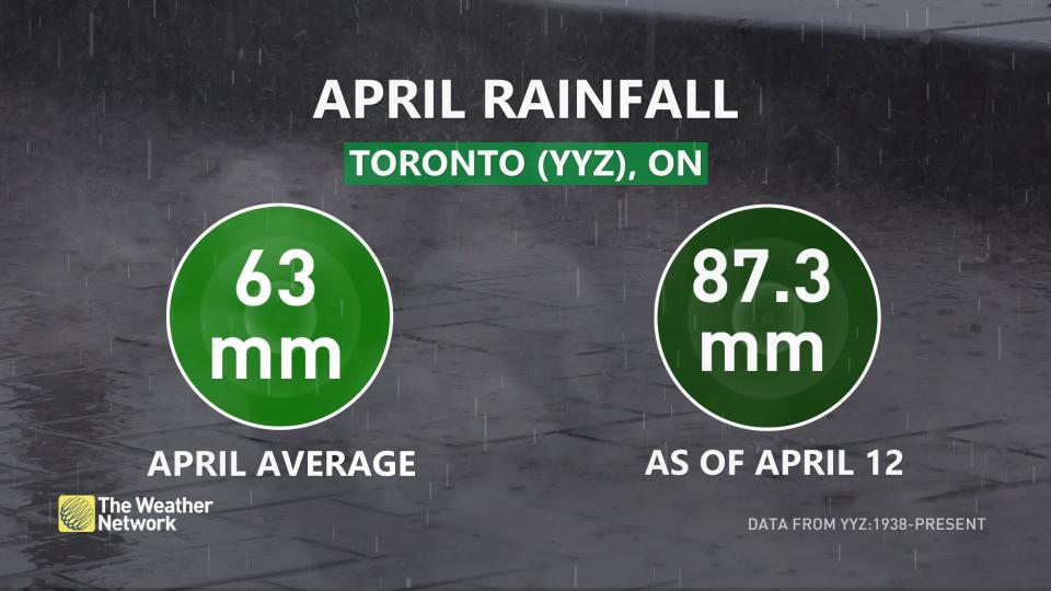
For Toronto, April has already been above normal for rainfall. A typical April sees 63 mm of rain at Pearson International Airport, but so far this month, as of April 12, the site has been hit with 87.3 mm –– 139 per cent of its average.
With a little more than half of the month still to go, Pearson will add to that total.
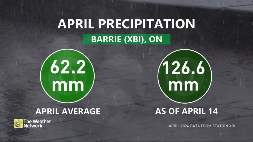
Barrie, Ont., has seen even more rainfall than Toronto, and leads the way in precipitation anomaly this month. It is now at 204 per cent of its average April precipitation through first two weeks of the month, as of April 14.
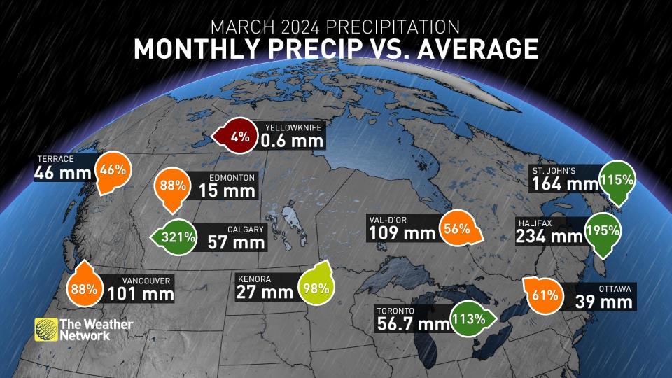
March was also a wet month for Toronto, with 56.7 mm of precipitation –– 113 per cent of its average.
While many Ontario residents have been dismayed by the rainfall, the precipitation does mean a somewhat lessened threat for drought and wildfires, both prevalent in northern parts of the province in summer 2023.
Ontario's wildfire season officially kicked off on Monday, April 1, and runs through Oct. 31.
Looking at the most-recent drought map, courtesy of Agriculture and Agri-Food Canada as of March 31, there are just a few pockets of dry conditions in southern Ontario. However, when you head north and east, the conditions get drier. A large swath of Ontario, extending from Ottawa to the Ontario-Manitoba border is considered dry, so these April rains are beneficial.
Within the northwestern section of the province, though, much of that region is in a moderate drought, with pockets of severe peppered near Lake Superior and just east of the Ontario-Manitoba border.
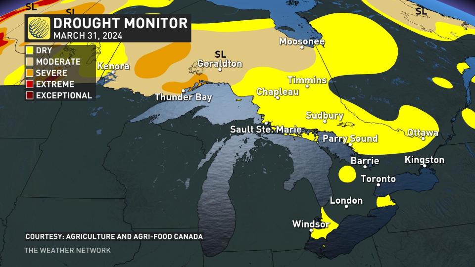
It should be noted that when the next drought monitor map is released at the end of this month, conditions will likely have changed in many locales, whether for better or worse.
While the recent rainfall will be beneficial, as well as the three-day snowstorm in March in Thunder Bay, Ont, at least one expert says we can expect an active wildfire season in Ontario as a result of the milder winter.
"We didn't have much of a snowpack out here in Ontario, especially in southern Ontario, and that means our ground is not as protected and it's not getting as much moisture," Anabela Bonada, manager and research associate at the Intact Centre for Climate Adaptation at the University of Waterloo, told CBC News.
"We have more dry debris on the ground and if there's any lightning or any sort of human-caused ignition, we could end up with quite a bit of wildfire this summer."
Thumbnail courtesy of Unsplash.

